
I took several days off work last week to eat up some use-or-lose time and attend to various things. Buddy and I both visited our doctors and came out with clean bills of health. Buddy's stitches from his second surgery are now gone and he's released from the doctor's care. My annual physical went well, with the doctor (and me) happy.

Saturday I checked another “must see” off my list when I took a trip up the Dalton Highway to the Arctic Circle.
Known to long-time Alaskans as the Haul Road, the Dalton Highway starts about 84 miles north of Fairbanks and ends at Deadhorse just a few miles from Prudhoe Bay and the Arctic Ocean.
The road was built in five months in 1974 to accommodate the trucks hauling supplies and equipment to facilitate construction of the Trans-Alaska Pipeline. Access to the Haul Road was limited until 1994, when it was opened for public use.
The Arctic Circle Wayside, our destination, is maintained by the Bureau of Land Management and is located at Mile 115 of the Dalton.
The road was bumpy and at times dusty despite the “scattered showers” we encountered. There were numerous curves and even more hills. Traffic was lighter than I expected, but we did encounter several personal autos and semis, as well as a few bicyclists and motorcyclists. Roadside litter, surprisingly and pleasingly, was minimal.
Knowing the road was unpaved and not easy on vehicles, my traveling buddy and I opted to let someone else do the driving. We signed up for a tour offered by an agency on the Army post where we both work. We joined our driver Jay and eight other passengers, all of whom are either new to Alaska or visiting. Not only did this save our cars from a possible beating, it afforded us the opportunity to sit back and watch the scenery go by. And go by it did.
This is not your run-of-the-mill drive through boring wilderness. The landscape seemed to change every couple of miles.
We drove through boreal forests, with white spruce, alder, willow and birch trees crowding the side of the road. Around the next curve, the trees disappeared and we were treated to a view of flat (or it appeared flat) tundra with just a few small bushes or trees scattered haphazardly. The next curve revealed spindly, misshapen black spruce trying to survive in the permafrost. The pipeline was visible for much of the trip. And mountains – everywhere we looked, there were mountains on all sides of us.


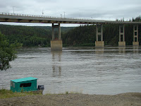
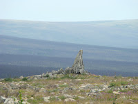
North of the Yukon River bridge, we were awed by huge fuschia patches of fireweed, signaling regrowth of areas damaged by wildfires several years ago. Just 17 or so miles before the Arctic Circle Wayside, we came to Finger Rock, a large granite rock that resembles a finger pointing toward Fairbanks. Other rocks dot the immediate area, with small arctic plants pushing their way up through the ground.
 Just 17 or so miles before the Arctic Circle Wayside, we came to Finger Rock, a large granite rock that resembles a finger pointing toward Fairbanks. Other rocks dot the immediate area, with small arctic plants pushing their way up through the ground.
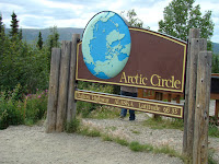
Nearly every traveler making this trip wants his photo taken next to the Arctic Circle sign. There’s a viewing stand to look out at the mountains of the Brooks Range with a couple of interpretive signs explaining a little about the area.

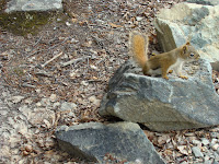
Every book and website I checked out promised great wildlife viewing on the trip. We could see moose, caribou, bears, fox, marmots and more, they said. I saw eight ravens, one squirrel, one gray jay, one white-crowned sparrow and lots of mosquitos and flies. Disappointing as that may have been, the trip itself was in the excellent category.

No comments:
Post a Comment